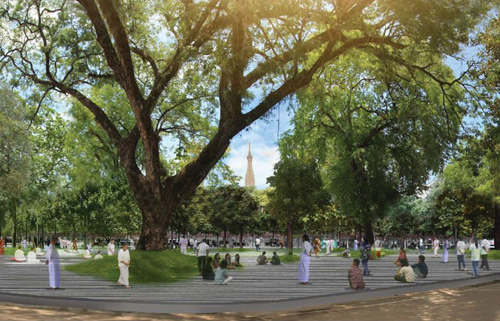
ลานกีฬาพัฒน์ 2
Public Space-Large Area: Excellent Award
“This is a role model and inspiration for creating a public space from the abandoned area. Several engagement activities were arranged for the collaboration between institutions and the community. This is not easy and requires an extensive amount of effort to push forward the project. The design is simple and requires only minimum maintenance. The function inside is well connected and opened, not creating an opaque enclosed space.”
2019 AWARDS JURY
Project Summary :
Bangkok Shaded line (Lankila Pat 2) is one of the projects from Lankila Pat, the project that initiated by the King Bhumibol Adulyadej.
Lankila Pat have 2 major objectives
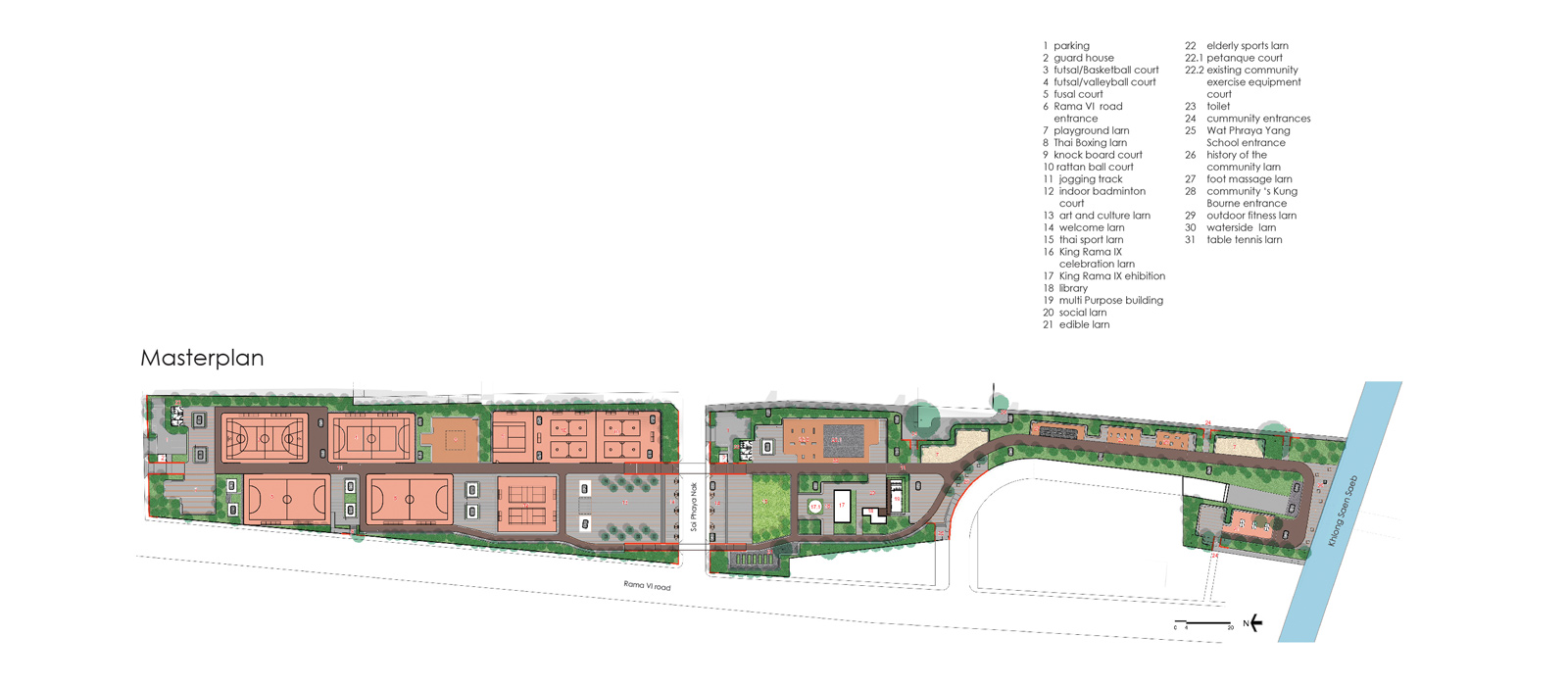
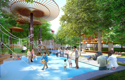
1.Utilize the unutilized space, to develop the abandon space to make the benefit for the community. 2.Developing the human recourses to have a good health and mentality by using the sports and the participatory design process to strengthen its own community. Site is located in the middle of Bangkok (Urupong) under the expressway. The concept of Thai basement (Larn-barn-larn-din) are used to refer the expressway as a house and designed the space to connect the relationship between the communities. We can separate the site to the northern part and the southern part. The northern part is active zone base on the existing condition (concrete surface) and activities (football Takraw Badminton and Boxing). We used participatory process to design the number of each sport fields and some sport fields have to be multipurpose. The southern part is passive zone base on the existing condition (unutilized land) and surrounding. This part has a lot of existing trees, and it connects to the communities and school. In participatory design process we found that we have to setback site boundary for public use as a walkway to their communities when the park is closed. This project could be the pilot project that use participatory process to design the area under the expressway. If we can utilize the unutilized space the expressway into the public space so this can be new green infrastructure that connect public spaces in Bangkok together.
ชื่อโครงการ : ลานกีฬาพัฒน์ 2สถานที่ตั้ง : ถนนพระราม 6, อุรุพงษ์, กรุงเทพมหานคร
LANDSCAPE ARCHITECT : บริษัท ฉมาโซเอ็น จำกัด
หัวหน้าโครงการ : ยศพล บุญสม
ภูมิสถาปนิกโครงการ : กิรินทร์ ตั้งเลิศปัญญา, เหนือฝัน ติณรัตน์
Client/Owner : สำนักราชเลขาธิการ สำนักงานกองทุนสนับสนุนการสร้างเสริมสุขภาพ(สสส.)
ผู้รับเหมางานภูมิทัศน์ : บริษัท สยามไพศาลกิจ(1995)จำกัด
Photography Credit : Panoramic Studio
หน่วยงาน/บุคคลอื่นๆที่ส่วนร่วมในผลงาน
กรุงเทพมหานคร การทางพิเศษแห่งประเทศไทย การเคหะแห่งชาติ สำนักงานทรัพย์สินส่วนพระมหากษัตริย์ กรมธนารักษ์ การกีฬาแห่งประเทศไทย กรมโยธาธิการและผังเมือง คณะกรรมการกิจการกระจายเสียง กิจการโทรทัศน์ และกิจการโทรคมนาคมแห่งชาติ (กสทช.) บริษัททางด่วนกรุงเทพ จำกัด (มหาชน) บริษัท ปตท.สำรวจและผลิตปิโตรเลียมจำกัด (มหาชน) บริษัท ปตท. จำกัด (มหาชน) บริษัท ปูนซิเมนต์ไทย จำกัด(มหาชน) บริษัท อิตาเลียนไทย ดีเวลลอปเมนต์ จำกัด (มหาชน) การไฟฟ้านครหลวง กรมอุทยานแห่งชาติ สัตว์ป่า และพันธุ์พืช การประปา นครหลวง การไฟฟ้าฝ่ายผลิตแห่งประเทศไทย สถาบันอาศรมศิลป์ และบริษัท เทเวศประกันภัย จำกัด(มหาชน)
ลักษณะโครงการ :
Public Space: Large Area
แนวคิดหลักของโครงการ :
โครงการลานกีฬาพัฒน์ 2 เป็นโครงการในพระราชดำริของในหลวงรัชกาลที่ 9 โดยพระองค์ได้ทรงตระหนักถึงความสำคัญของกีฬาที่จะสามารถใช้เป็นเครื่องมือในการสร้างชุมชนเข้มแข็ง โดยโครงการลานกีฬาพัฒน์ ต้องการพัฒนาทรัพยากรมนุษย์ให้มีสุขภาพทั้งทางกายและทางใจที่ดี และใจที่ดี พัฒนาคุณภาพชีวิตของชุมชนให้มีความเข้มแข็งสามัคคี และเปิดโอกาสให้ชุมชนมีส่วนร่วม ทั้งในกระบวนการออกแบบ การก่อสร้าง และการจัดการ
ลานกีฬาพัฒน์ 2 ได้ใช้กระบวนการออกแบบอย่างมีส่วนร่วม เข้ามาออกแบบพื้นที่ที่พัฒนาไม่เต็มประสิทธิ ให้สมามาถใช้งานดีภายใต้ข้อจำกัดของพื้นที่ มีการพยายามดึงเอาจุดแข็งของทางด่วนมาใช้ เพื่อให้สามารถจัดกิจกรรมได้ตลอดวัน เพิ่มแสงสว่างในเวลากลางคืน และการป้องกันฝุ่นละอองด้วยพื้นที่สีเขียว
รายละเอียดโครงการ :
1. The intro
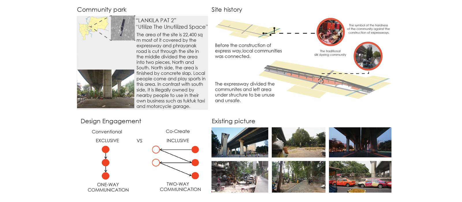
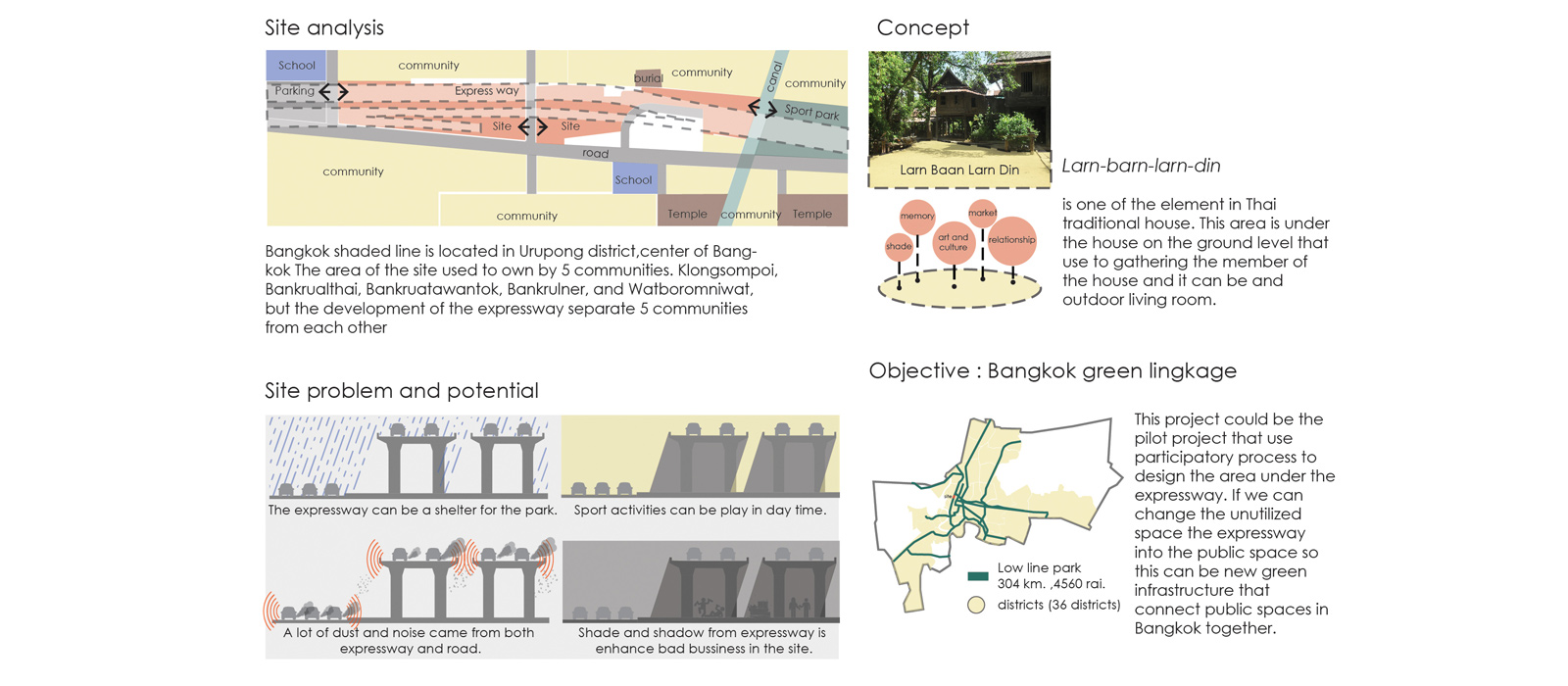
Bangkok is one the most traffic jam city in the world. People usually travel with their own vehicles and spend time 1.6 hours per day on the road. The number of road and expressway are increasing in contrast with green and open spaces; the number of green area for Bangkok is only 5 sq m per person while the world health organization(WHO) indicated the number of green area at 9 sq m per person. The expressway is one of the solutions for solving the traffic jam but in the same time it also creates the problems because it separates the area between districts in the city and the area below the expressway become abandon. However this area has potential to develop into the new green infrastructure to connect the public spaces in Bangkok.
2. The site
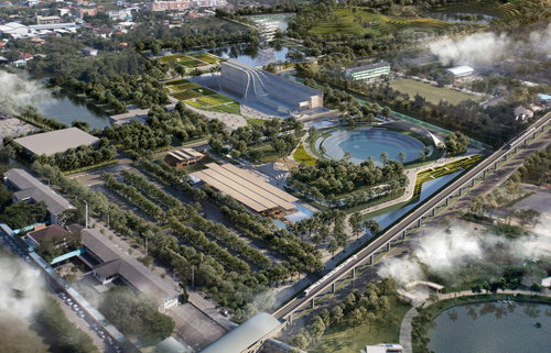
Bangkok shaded line is located in Urupong district, center of Bangkok. The area of the site used to own by 5 communities, Klongsompoi Bankruatai Bankruatawantok Bankruner and Watboromniwat, but the development of the expressway separate 5 communities from each other.
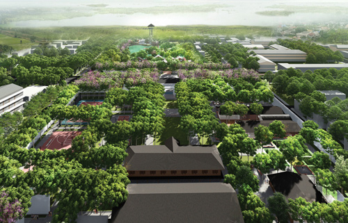
The area of the site is 22,400 sq m most of it covered by the expressway and phrayanak road is cut through the site in the middle divided the area into two pieces, North and South. North side, the area is finished by concrete slap. Local people come and play sports in this area. In contrast with south side, it is an unutilized area.
3. The Design
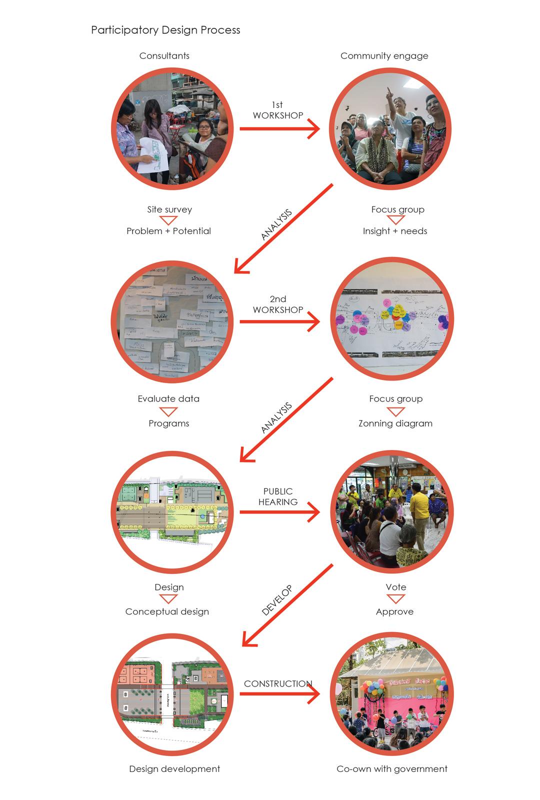
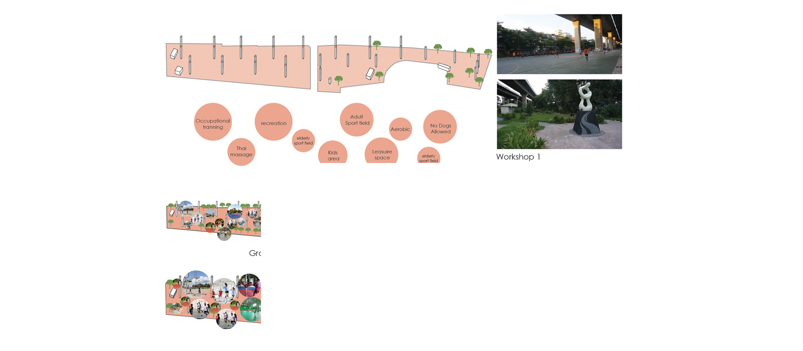
-Participatory design
Participatory design process with the communities and stakeholder is not only provide the programs that fit to each communities but also give the opportunities to local people to be in the part of design process, construction process and management after the park finished by this local communities will have the sense of ownership of the park.
-Master Plan Concept
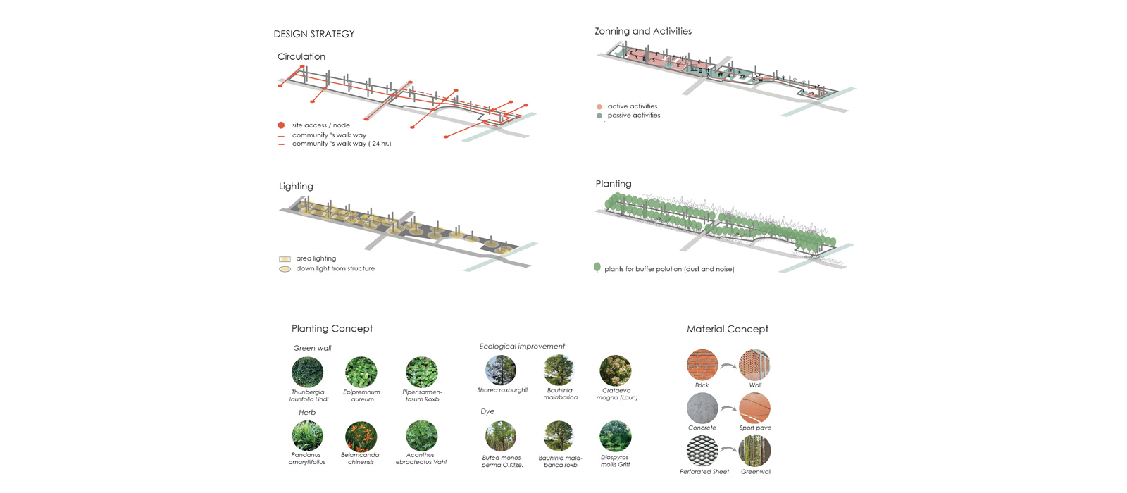
Larn-barn-larn-din is one of the element in Thai traditional house. This area is under the house on the ground level that use to gathering the member of the house and it can be and outdoor living room. Larn-barn-larn-din can be refer in landscape element as the space that connect the relationship between the communities. The shading from the expressway create the atmosphere of the space under Thai house like Larn-barn-larn-din.
Material concept, local materials are selected in this project such as concrete and steel. Larn-din is mean soil terrace so brick is used to refer to soil material. Pattern of the brick can also refer to the technique of weaving which very famous in Bankrua community.
Planting concept, native plants and plants that absorb the pollution are selected to plant on the boundary of the site. Yellow flowering plants are selected as the symbol of the king. Edible garden is planted as one of the activity that came from the workshop. Plants that can be used in weaving business are also planted to relate the history of the site.
Lighting concept, lightings are attached on the existing structure and new structure to create the general lighting in the park.
-Design strategies
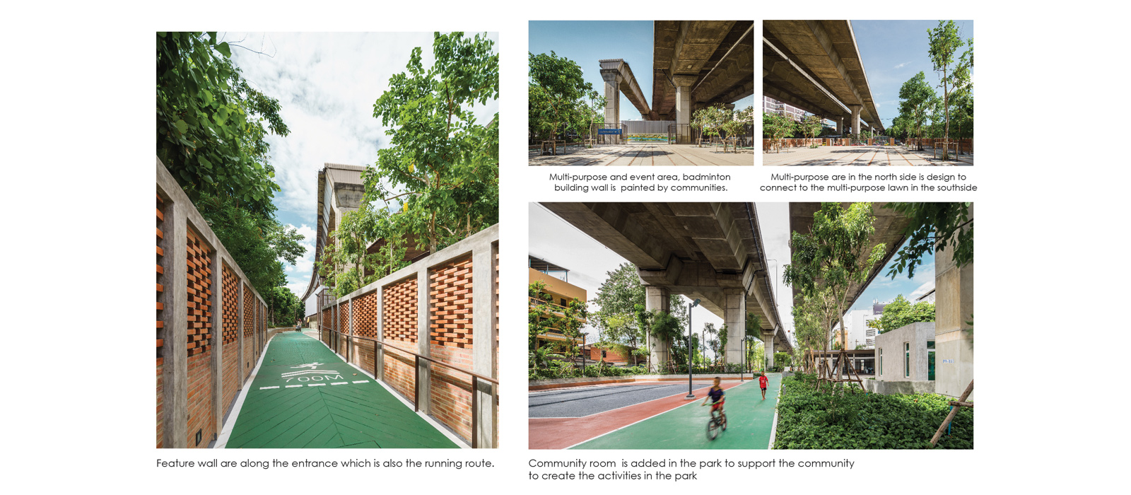
Connect site connect people, the design aim use site as a platform to connect 5 communities around the site. Main gate in south side and north side are the key to connect both side together. Other gates are linked the communities to communities and the communities to public infrastructure.
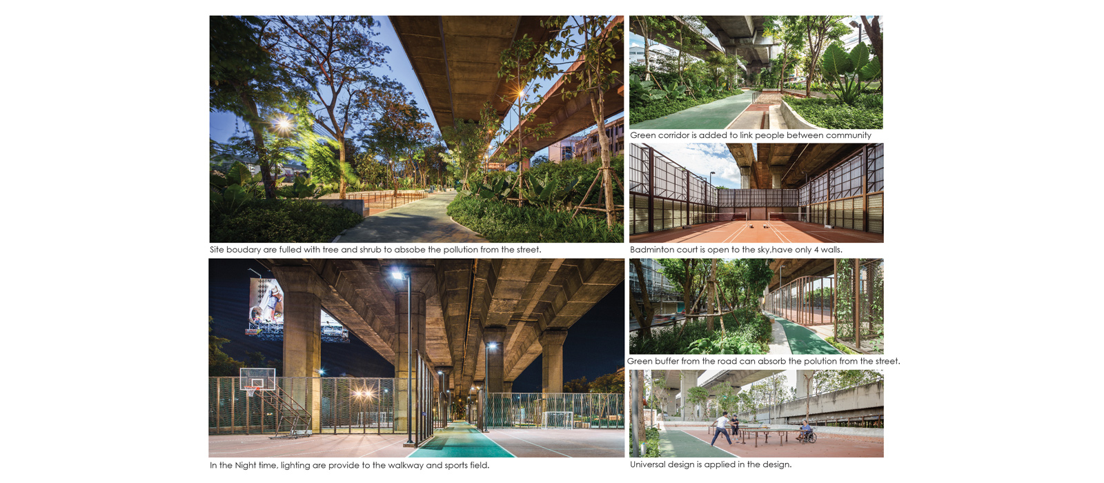
Grouping activities and identify the location, grouping active activities on the north side, more concrete surface and under the shade of the expressway, and passive activities on the south side, soil surface. Created the boundary in shape of horseshoe between the sports activities such as futsal, basketball for safety but it is still can connected on one side. Sports activities can play in daytime by using the shade from the expressway.
Green filter as the boundary of the site, trees and shrubs are planted on the boundary of the site because of the shading from the expressway and it works as the green filter to absorb the dust and the pollution from the street.
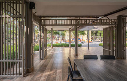
Existing structure as the new infrastructure, existing column can be used as the new infrastructure such as lighting, seating and green wall.
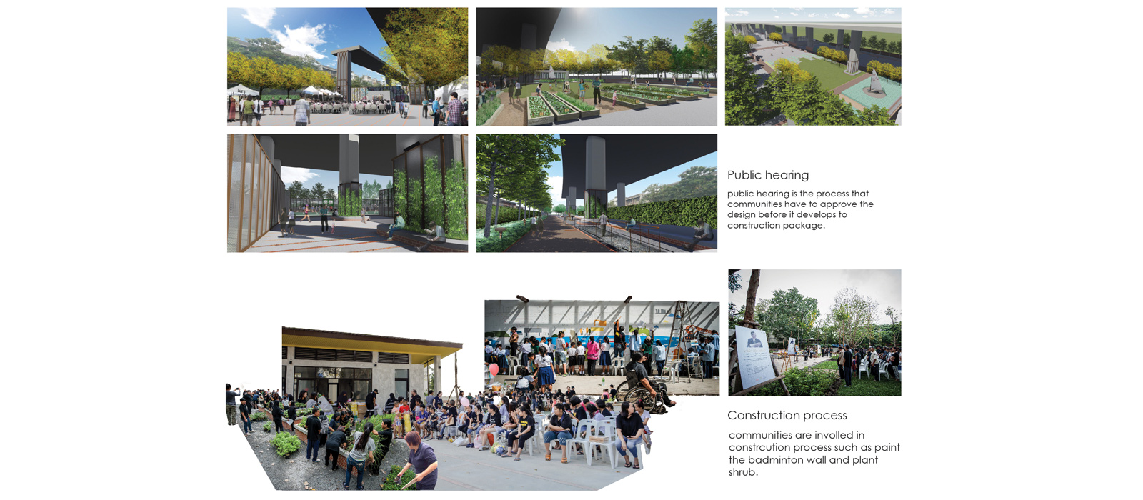
5. The Construction
During the construction process some events are created to let the local communities to be in the part of the park such as plant some area of the shrubs, paint the wall of the badminton building and paint the floor on the playground. This process is created sense of belonging to the local communities.
6. The Management
After construction completion, local communities must select their representative to become the committee to manage the park with the representative from the government parties. By this local communities can easily ask for the permission to use the park for their annual events.
7. The Future
This project could be the pilot project that use participatory process to design the area under the expressway. If we can change the unutilized space the expressway into the public space so this can be new green infrastructure that connect public spaces in Bangkok together.